
For Austin and the surrounding Central Texas region, the benefits are tangible. A more resilient I-35 corridor supports mobility and commerce. Better stormwater infrastructure reduces flood exposure. Photo Credit: TxDOT
By Will Parnell, PE – Parnell Engineering, Inc.
The hidden engineering behind Austin’s bold flood resilience vision.
The part of the I-35 rebuild most people will never see may be the part that matters most
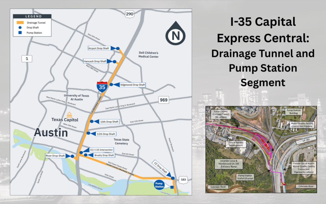
When people talk about the future of I-35 in Austin, they usually picture what will happen above ground: a lowered interstate, reworked crossings, improved pedestrian and bicycle connections, and the long-term possibility of caps and stitches that reconnect parts of the city long divided by the corridor. But one of the most important pieces of the entire effort is happening far below the surface. As part of TxDOT’s I-35 Capital Express Central project, the state is building a major drainage tunnel and pump station system designed to protect the lowered highway from flooding and strengthen stormwater performance across a critical stretch of Austin. The larger Capital Express Central project spans about eight miles from US 290 East to SH 71/Ben White Boulevard and is part of a broader reconstruction intended to improve mobility, safety, and multimodal connectivity through central Austin.
Why a lowered highway demands extraordinary drainage engineering
Lowering I-35 creates new opportunities above ground, but it also creates a serious engineering challenge below ground. Once the mainlanes sit lower than the surrounding terrain, stormwater cannot simply follow older drainage patterns and be expected to perform the same way. TxDOT’s project materials say the new lowered mainlanes would interrupt the existing drainage system, which is why the drainage tunnel is being built to prevent the reconstructed section of I-35 from flooding. Just as important, TxDOT says the work is intended to benefit the greater community, not only the highway itself.
The underground system is massive, precise, and deeply technical
The scale of the tunnel work is remarkable. Current TxDOT materials describe 6.5 miles of 22-foot-diameter drainage tunnels extending between Airport Boulevard and Holly Street and along Cesar Chavez Street to US 183. The tunnels are planned at depths ranging from roughly 70 to 200 feet, and the system includes nine deep shafts along the corridor for access, maintenance, operations, ventilation, and tunnel retrieval. TxDOT also states the tunnels will be mined by two shielded rock tunnel boring machines. In a January 2026 update, TxDOT said those machines are expected to arrive from Germany.
This is not just a tunnel project, it is a full stormwater management system
The drainage tunnel is only one part of the solution. TxDOT’s plans also include a major pump station at Cesar Chavez Street and US 183. Public project materials describe a 14,500-square-foot operations building, about 1,370 feet of reinforced concrete tunnel to provide gravity flow at higher levels, pumping capacity of roughly 130,000 gallons per minute, and a large mechanical trash screen. Together, these elements turn the project into far more than a buried pipe. This is a coordinated system for collecting, conveying, screening, pumping, and managing stormwater under highly constrained urban conditions.

One of nine drop shafts being drilled for the I-35 tunnel project. Photo credit: TxDOT
Why this matters beyond the highway
Flood protection is the headline benefit, but it is not the only one
TxDOT says the tunnel and pump station will help prevent the lowered I-35 mainlanes from flooding, but the public value extends much further. Project materials say the system is intended to reduce flood risk in the Boggy Creek and lower Waller Creek watersheds, reduce runoff entering the existing Waller Creek tunnel, and improve water quality by removing trash and some sediment before discharge. TxDOT also says the effort is being coordinated with the City of Austin on a large regional water quality pond that will treat water before it reaches the Colorado River.
The floodplain impact is especially significant
One of the strongest indicators of the project’s long-term value is its projected effect on flood risk. TxDOT’s 2025 community materials say the work would reduce the 100-year floodplain in the Waller Creek and Boggy Creek watersheds by more than 190 acres. In practical terms, that means the project is not only protecting highway infrastructure. It is also intended to improve resilience for surrounding neighborhoods, properties, and public systems in a fast-growing urban corridor where flood management is inseparable from public safety and economic stability.
The cap and stitch vision depends on what happens below grade
The tunnel is part of a larger civic transformation
The drainage work also supports one of the most talked-about aspects of the I-35 rebuild: Austin’s cap and stitch vision. TxDOT’s project page says the lowered mainlanes and reconstructed crossings are being designed in coordination with future community connections, while the City of Austin has described caps and stitches as an opportunity to create public spaces over the corridor and reconnect neighborhoods historically divided by I-35. In 2024, Austin City Council materials stated the city was in the process of designing and funding 25 acres of caps and stitches over the corridor. Then, in May 2025, the city committed up to $104 million for Phase 1 roadway elements tied to the cap and stitch effort.
Great public spaces need great hidden infrastructure
That is what makes this such a compelling civil engineering story. The future caps and stitches may become the public face of the project, but the drainage tunnel is part of the invisible foundation that makes the vision possible. You cannot lower a major interstate, reduce flood vulnerability, improve multimodal crossings, and prepare for new public space without first solving the water problem with precision and confidence. In that sense, the tunnel is not secondary to the transformation. It is one of the core reasons the transformation can happen at all.
A lesson in engineering at city scale
This is what integrated infrastructure looks like
What stands out most about the project is not only its size, but its coordination. Deep tunneling, shaft construction, hydraulic design, pump station operations, water quality treatment, construction mitigation, and urban design all have to work together. TxDOT’s materials also describe planned measures for vibration, noise, and dust mitigation during construction, underscoring that infrastructure at this scale must perform technically while also managing impacts on the surrounding community. That is the kind of systems thinking that defines high-level civil engineering.
The real brilliance is in what the public gains
For Austin and the surrounding Central Texas region, the benefits are tangible. A more resilient I-35 corridor supports mobility and commerce. Better stormwater infrastructure reduces flood exposure. Improved water treatment helps protect downstream resources. And the groundwork for caps and stitches opens the door to reconnecting neighborhoods and creating new public value above a corridor that has long functioned as a barrier. This project is a reminder that some of the most visionary infrastructure is not the part people photograph. It is the part engineered with such intelligence that, over time, the city above it works better, feels safer, and becomes more connected because of it.
Parnell Engineering, Inc. provides comprehensive Drainage and Water Master Planning services for municipalities, utility districts, and private clients throughout Texas. Our experienced team combines hydraulic modeling expertise, regulatory knowledge, funding support, and a deep understanding of Texas flood and water challenges to deliver plans that work in the real world, not just on paper.
Contact us today at 512.431.8411 or visit www.parnellengineeringinc.com to learn how we can help your community.
Related Articles
From Raw Land to Build Ready: A Developer’s Guide to Site Development in Texas
Whether you're buying your first tract of land or expanding an existing portfolio, understanding the site development process before you invest can save you time, money, and a great deal of frustration. By Will Parnell, PE - Parnell Engineering, Inc. Owning land in...
Nesting Season Is Coming: What Land Developers Need to Know About the Golden-Cheeked Warbler
March through August brings critical federal protections that can directly impact your project timeline — here's how to plan ahead. By Sarah Parnell, Certified Wildlife Biologist and USFWS GCWA Permit Holder If you're planning land development, site clearing, or...